

Kayaking Fiordland in BC’s Great Bear Rainforest
Our kayak trip to Fiordland, part of the Great Bear Rainforest, was different. It was like no other paddling trip that we have ever done, which have largely been coastal trips with exposure to the open ocean. Trips like these generally offer a decent selection of beaches, bays and sheltered coves where you can land and camp. Paddling the fiords of the Great Bear Rainforest challenged that vision of kayak tripping since these deep fiords have very little space for shore exploration, camping or for that matter, even finding a place to hop ashore for a pee break. It is also worth mentioning that getting in and out of kayaks as we push through our 60’s isn’t as easy as it once was. So, even when we found a spot that looked promising, getting out of the boats was often more of a challenge. Let’s just say that not all of our landings were graceful!

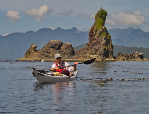
Kynoch Inlet
The Fiordland Conservancy
The Fiordland Conservancy is a very large marine park located on the central coast of British Columbia. It encompasses Mussel and Kynoch Inlets, their estuaries and the surrounding mountainous landscape. The park is located within the bounds of The Great Bear Rainforest, a global treasure covering 6.4 million hectares on British Columbia’s north and central coast.

Mathieson Channel
The fiords of this area were carved out by glaciers during the last Ice Age and reached their maximum coverage approximately 20,000 years ago. It would be another 6,000 years before they began to retreat. In places there are spectacular sheer granite cliffs rising more than 1,000 metres from the water. The mountains are covered in dense coastal forests. Lush river estuaries and thunderous waterfalls drop from incredible heights into the waters of the fiords. The shear number of inlets and islands in this area create an immense length of shoreline. The vegetation is dense and impenetrable and many areas are home to grizzly and black bears including the ’Spirit’ or ‘Kermode’ bear a rare subspecies of the American black bear, which create a further obstacle to camping here. We never saw any bears and had planned our trip to avoid the most likely bear habitat areas in order to avoid any conflict. As you may expect, the area is largely uninhabited but this is part of the appeal for wanting to explore this region.

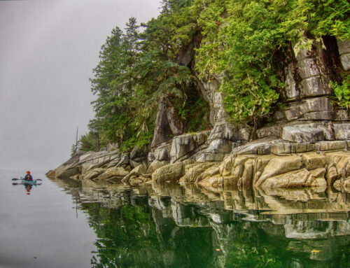
Steep Granite cliffs in Sheep Passage
The Trip
Our trip to Fiordland began at the BC Ferry Terminal in Port Hardy, British Columbia, near the northern tip of Vancouver Island, approximately a 6 hour drive from Victoria where we live. Here we leave our vehicle behind and load our kayaks and gear onto a BC Ferries’ kayak trailer and baggage carts. We walk onto the BC Ferries ‘Northern Expedition’ for a 7 1/2 hour trip north to the First Nations community of Klemtu, located on the northeast side of Swindle Island on the Inside Passage. Aside from a short stretch of open ocean between Vancouver Island and Rivers Inlet, where the Central Coast archipelago begins, the route north to Klemtu leads through a narrow maze of channels and passes making for a spectacular ferry ride!

Boarding the Northern Expedition in Port Hardy
Klemtu
Klemtu is a more recent First Nations settlement, founded in 1870 to provide wood and supplies for the growing steamship service running through the inside passage. Today, it has a population of around 500 people and is primarily composed of two First Nations groups the Kitasoo (kit-ah-soo) and the Xai’xais (hay-hace). Klemtu is the starting point for anyone wanting to explore this area either on their own or through tours. One local tour company, owned and operated by the local First Nations band, has opened the stunning Spirit Bear Lodge to house visitors while offering eco-cultural and wildlife-viewing tours that include trips to Princess Royal Island and the Fiordland Conservancy Marine Park. Of course, one of the major draws for people taking tours up here is the chance to see the famous ‘Spirit’ Bear.

Klemtu
At the Klemtu terminal, the BC Ferries crew pull the kayak trailer and baggage carts onto the ramp for unloading. The ferry used to dock in Trout Bay, right in Klemtu where the band-run cannery, the government dock and the Big House are located (we landed here on a previous trip: Kayaking Klemtu to Bella Bella). But the new terminal, built to accommodate larger ferries like the ‘Northern Expedition’, is now located 1.5 km north of the village.

Unloading the kayaks at the Klemtu ferry terminal
Launching here will be our first introduction to some of the difficulties of this trip. There is no boat ramp into the water at the new ferry terminal and there is no beach, just a shoreline made from large, very sharp, blasted rocks used in the construction of the ramp and dock. There is also no good path from the roadway down to that shoreline. What you have is a truly nasty class 5 put-in, (a classification for whitewater meaning extreme risk), which risks twisted ankles and broken kayaks as you struggle to get gear to the waters edge and heavily laden boats off the sharp rocks into the water.

Loading Gear at the Klemtu Ferry Terminal
The Paddling Begins
The Ferry arrives in Klemtu around 3 in the afternoon. Loading 2 weeks worth of food and gear into kayaks is a bigger challenge and is always slower on the first day of a trip because of the maximum volume of gear and not having the perfect packing system yet worked out. Loading gear on this treacherous beach delays us even more and we don’t get on the water until 5:45 pm. To make matters worse the nearest campsite on Sarah Island is about 5.3 nm (nautical miles are equivalent to 1.15 mile or 1.85 km) north up Hunter Channel. This also means we will have to reverse most of that distance in the morning to get back to the southern tip of Sarah Island so we can begin our passage of Finlayson Channel. Such are the challenges of Fiordland. However, on the plus side the days are long so at least we don’t have to worry about setting up camp in the dark.

Boat Bluff Light Station
We land on a sandy beach at Sarah Island and are able to find some decent tent sites for the night. In the morning we load our boats at low tide on a beach of mud and shells and as we depart the water is thick with small translucent jelly fish. The sun is out and the winds are calm making for a very pleasant start to the paddle back to Boat Bluff at the southern tip of Sarah Island. There is a large light station at Boat Bluff, which is also the source of the local weather information.

Loading the kayaks for departure from Sarah Island
We have a surprise waiting for us as we approach Boat Bluff, there are humpback whales feeding in the waters just off the light station, their blow spouts easily visible against the flat calm water and their huge flukes dripping sparkling water as they begin their dives.

Humback Whale Blowspout off Boat Bluff

Humback diving off Boat Bluff

Humpback Whale off Boat Bluff looking south down Finlayson Passage
Once we rounded the tip of Sarah Island we began the 2 nautical mile crossing of Finlayson Channel. Finlayson Channel is wide, very long and very exposed with the possibility of strong winds being funneled along it. Fortunately for us is was like a mill pond with hardly a ripple so we take a long angling path across the channel.
After about 4 hours in the kayaks we finally managed to find a place on the eastern shore where we could get out of the kayaks for our first break of the day. It was nothing more than a some flat rocks near the waters edge. Embarrassingly, between the awkward landing site and aging, aching bodies that had been too long in the boats, our exit from the kayaks was not pretty. We had to leave the boats floating as there was no room to get them out of the water. You definitely want a bowline on your kayak for situations like this to be able to easily secure the boats.

Starting across Finlayson Channel

A long awaited chance to stretch our legs at a dubious takeout after crossing Finlayson Channel
Our next camp was not far off at Wallace Bight. On our initial approach we didn’t locate the campsite as it is hidden from view by a very small island. From a distance and our low perspective in the water it was impossible to distinguish a break in the shore line, so the island just looked like an extension of the rocky shore. After a lunch on another part of the bay and a closer look at our charts, we got back in the boats and paddled in closer and finally found what we were looking for, a beautiful sandy beach with an nice campsite tucked in behind the island.

Hidden behind a small island, the beautiful Wallace Bight Campsite
Leaving Wallace Bight in the morning, we continued north up Finlayson Passage along the western edge of Roderick Island. Paddling this shoreline at low tide is spectacular because of the the amount of sea life clinging to the rocks. The numbers of variety of colours of the sea stars, brittle stars, sea anemones, shell fish etc was truly amazing. As we continued around the coast of Roderick there was literally no where to land a kayak as it was all steep rock faces dropping straight into the water. Once around the north shore we finally found a potential spot, a boulder strewn beach covered in rock weed. The footing was treacherous but at least we were able to get out of the kayaks for a desperately needed pee break! Once back in the boats we paddled past a large fish farm located in Kid Bay and crossed the channel to Carter Bay, a large bay on the north side of the channel with sand and gravel beaches.

Sea Life clinging to the rocks along Roderick Island

Steep rocky shoreline along Roderick Island
A Shipwreck
Carter Bay is known for the wreck of the Alaskan Steamship Company steamer the SS Ohio, which was intentionally run aground here in 1909. This iron steamer was serving the Seattle to Nome route when she struck an uncharted rock in Hiekish Narrows on Finlayson Channel. The ship was critically damaged and taking on water to the point where the boilers exploded. In spite of this the captain managed to beach the ship on a sandbar in Carter Bay saving all on board. Today there is not much left to see of the wreck and portions of it only appear above the surface at low tides. We searched for the wreck of the Ohio as we paddled into the bay expecting to see at some sign of the wreckage, but the tides were fairly high and we found nothing.

The remains of the SS Ohio in Carter Bay at low tide
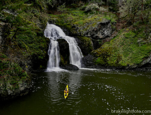
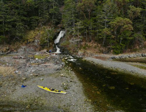
The campsite in Carter Bay is located on the north shore of the bay with a sand and gravel beach. We found some lovely tent sites back in the trees with a huge vertical rock face forming a backdrop to the site. There is also a good size river, Carter Creek, flowing into the Bay from Carter Lake located back up in the mountains. A short but pleasant paddle up the estuary brings you to a good size waterfall. At sometime in the near past there must have been a terrific storm through here as there are an incredible amount of trees blown down all along the estuary. Fortunately, the water way was clear and I was able to paddle up to the rapids just below the waterfall. Since the sun was out and the temperatures warm, it was a perfect spot for a fresh water swim and chance to get cleaned up!

Waterfall on Carter Creek

Campsite at Carter Bay, BC
Our departure from Carter Bay was near low tide, and even though it meant a long carry from the campsite to the waters edge we were hoping we might get a glimpse of the ship wreck. Indeed there were some portions of the hull protruding from the water as we paddle past and we could see the curving shape of the bow resting on the sandbar just beneath surface of the clear waters of the bay.

Wreck of the SS Ohio at low tide
As we exited the bay we turned east up Sheep Passage with it’s high soaring rock faces. With light winds at our back and sunshine on our faces we headed down the fiord. We had picked a potential beach on the south side of the passage only about 6.4 nm away as we wanted to spend some time in the fiords. However, the timing of our arrival at this campsite was definitely sub-optimal, leaving us a long long way from where we needed to set up camp on the high berm. To make our lives easier we tied the boats to a long anchor line and let the tide float them to us while we enjoyed our lunch. This campsite allowed us our first glimpse east down the fiords at mountains tall enough to still have snow on the peaks in July.

Sheep Passage

A very long walk from the water at low tide, to our campsite on Sheep Passage
We planned our departure from Sheep Passage early enough to be ahead of the mornings low tide in order to avoid the long carry across the sandbar which caught us the day before. It was a relatively short and easy paddle to Heathorn Bay just on the other side of Mathieson Narrows, the entrance to Mathieson Channel which runs south 56 km along the Don Peninsula. The passage into Mathieson Narrows is quite interesting passing under high, colourful, smooth rock faces on the south side of Sheep Passage. There high steep hillsides all around and the area has a real ’Lord of the Rings’ feel to it.
Currents can be quite strong in the narrows, and if you happen to be here when the ebb or flood is against winds running up the inlets it apparently can get quite gnarly. On this day we cross in mild currents and light winds without issue. Sadly, the campsite in Heathorn Bay left a bit to be desired. It is located at the base of some very steep hills making it quite gloomy and all the debris that blows up the length of Mathieson Channel ends up on the steep cobble beach. There were large stacks of kelp on the beach, making it a little awkward to get around and to make matters worse, the black flies were horrendous!

Picturesque Rocks at Mathieson Narrows

Looking Northeast up Mussel Inlet from Mathieson Narrows

Checking the weather on the VHF Radio and planning next days paddle at Mathieson Narrows
The morning of our 6th day saw the beginnings of a change in the weather and there were high winds and rain in the forecast. Looking up Mathieson Channel we could see the looming dark clouds and oncoming squalls. We were up early to try and beat the worst of it but we were still faced with light headwinds and choppy seas as we set out down the channel.
Our plan was to make for a bay on the east side of the channel with a north facing beach, which we hoped would give us shelter from the expected southerly winds. On our way we were able to find a spot to land just inside Garvey Point, one of the only spots along this part of the channel to take a short break. Leaving Garvey Point we paddled across the entrance to Kynoch Inlet, a spectacular fiord running east with huge rock faces soaring hundreds of meters out of the water. There is a huge waterfall plunging into the north side of the inlet from Lessum Creek and there are snow capped peaks in the distance. This spectacular area is truly the heart of Fiordland!

Lessum Falls, Kynoch Inlet
We eventually landed at the on a cobble beach interspersed with large boulders before the worst of the weather hit. The campsite was marginal and the only tent sites we could manage were leveled out on the large cobble above the high tide line. The forest was too dense and too boggy to provide and any chance of a better site. I’m definitely thankful for modern sleeping pads that enable you to sleep on stuff like this in relative comfort! Some positive notes of this site were a nice fresh water stream running off the hillside and the spectacular view looking north up the inlet at Mathieson Narrows.

Heading south on Mathieson Channel into worsening weather

Landing at our Campsite on Mathieson Channel – Mathieson Narrows, shrouded in rain showers, in the distance
It Begins to Get Wet
The rains began that afternoon and continued for the next two days without stop!. I guess that’s why they call this area a ‘rainforest’. It rained so much and so hard that the entire beach was more like a shallow river as it was completely awash in fresh water. It ran in streams under our tents and through our kitchen area. All we could do is sit on logs under our tarp, reading and eating to help pass the time and try to stay dry. In spite of the inclement conditions we were still able to enjoy the ever changing views of the rain soaked inlet, and the antics of a couple of Pacific loons in the bay. The rains finally let up around 6 pm on Friday, our third day in this sodden camp. Since the worst of the weather had passed, we planned on heading for Hird Point the next day.

Waiting out the rain with water running through the kitchen area at Mathieson Channel camp

Trying to stay dry

Our view up Mathieson Channel during periods of heavy rain – a pair of Pacific Loons
It was good to get back on the water after being camp bound for the last three days. The continuous periods of precipitation had swollen the lakes and streams so much that water was pouring off the mountain sides everywhere you looked. It was like they had sprung leak! We passed an incredible number of waterfalls on our way south to Hird Point. Some of these were plunging hundreds of feet into the inlet!
Hird Point is beautiful with a large river flowing into the bay on the north side. Sadly, as promising as it looked from the charts and the looking at it from the water, on closer inspection there were really no good campsites here. The grassy flat is strewn with large rocks with no spot big enough for a tent.
After some pleasant exploration in some well deserved sunshine, we decided to move on. In breezy conditions, we set out across Mathieson Channel to Rescue Bay where we found a decent cobble and grit beach on the south side of the bay with some good tent sites. Rescue Bay is very close to Jackson Narrows Marine Park and provides a good anchorage for boaters. In fact, that evening there were three boats at anchor in the bay.

Waterfall on Mathieson Channel

Exploring Hird Point for potential tent sites…looks great, but the grass hides the large rocks strewn everywhere

Crossing Mathieson Channel in breezy conditions on our way to Rescue Bay

Enjoying calm conditions and more importantly, no rain at Rescue Bay
The next morning we were greeted with sunny skies and calm winds for our departure from Rescue Bay. We turned our kayaks south heading for a campsite on Nathan Island about 12 nm away only stopping for lunch on a bouldery beach on the inside of Arthur Island. The landing at Nathan Island was not ideal either, the beach consisting of large kelp and barnacle encrusted rocks. However, we were able to find a good sites for our tarp and two tents with beautiful views looking over the inlet to the west.
We were a little cautious at first as there were signs that a bear had been through here fairly recently, with fresh scat and large areas of the ground rooted up where it was digging for Silverweed roots, but in the end we never saw a bear. As we sat around camp we could hear loud thundering claps in distance which turned out to be humpback whales breeching on the other side of the inlet.
This campsite was so pleasant we decided to spend an extra day to enjoy it, only taking a short paddle the next day around the east side of Nathan and Lake Islands for a bit of exploration and to collect some fresh water. We tried our hand fishing while over that way but with no luck, but once we returned to camp we tried our hand again in the bay just off shore, catching two very nice rockfish. Fried up with some olive oil and garlic…delightful!

Leaving Rescue Bay on a perfect morning

A sub-optimal landing zone on Nathan Island

Nathan Island Campsite
The next day’s paddle would take us further across the southern end of Mathieson Channel along with our first exposure to the open ocean of the trip. We followed Reid Passage down the inside of Cecelia Island to a lovely campsite on one of the Roar Islets located in Blair Inlet. This is a campsite we have visited before on our Klemtu to Bella Bella trip. It is a perfectly pleasant shell and gravel beach on a tiny islet with great views in almost all directions. Unfortunately, the rain showers began again as we approached, but at least they weren’t continuous.

Paddling down Reid Passage

Our Roar islet Campsite

Enjoying a sunset on the Roar Islets
This was another site worth spending an extra day, which allowed time for a day trip out and around Ivory Island the location of another beautiful west coast lighthouse located on the junction of Seaforth Channel and Milbanke Sound. There was some great fishing off Ivory Island, where we caught a couple of good sized rockfish and a lingcod. That meal would provide left overs for the next couple of days! We saw our first sea otters of the trip at the Roar Islets and an immature bald eagle provided some additional entertainment. Around mid-afternoon we watched as the BC Ferries ‘Northern Adventure’ made it’s turn at Ivory Island to begin its journey across Milbanke Sound, heading north towards Klemtu and onto Prince Rupert.

Paddling past the Ivory Island Light Station

Bald Eagle near Ivory Island

The Days Catch on the Roar Islets – Dugald Nasmith Photo
As we went to bed in the evening the skies were clearing so we were hopeful for some nice weather in morning. My first glance out of the tent in the morning showed nothing but grey and gloom. However, once dressed and out the door, I was pleasantly greeted by sunshine breaking out of a low fog bank. The mornings departure was perfection with the morning sun reflecting off the still waters of Blair Inlet. It is paddling days like this that you live for, sunny and warm, with nothing disturbing the water except the bow of your kayak and the dip of your paddle. It would be an ideal day for the 2 mile crossing of Seaforth Channel.

The sun burning through the fog over Blair Inlet on the morning of our departure from the Roar Islets

Crossing Blair Inlet in perfectly still water
We crossed Blair Inlet and slipped down the passage between Watch Island and the Don Peninsula turning east towards Fisher Point, the most southerly point on the peninsula. Here we searched for a totem pole that used to be seen rising out of foliage on the tip of the peninsula, but time has erased any trace of it that we could see. From here we set out across Seaforth Channel for Dufferin Island, part of the Bardswell Group, where we were able to eek out a campsite on a steep cobble beach. Since there were no possible tent sites under the trees, we had to make do with leveling some sites as high up the beach as possible. We were a little concerned about getting washed out since there was going to be a very high tide that night. Indeed, during the wee hours of the morning, the log I used as a berm to hold the cobble in place began to float and I spent a restless hour or so listening to the motion of the log as it moved up and down against the gravel. The water came within just a few inches of flooding the tent before the tide finally turned. Luckily it was a calm night!

Approaching Fisher Point on Seaforth Channel

Campsite on Dufferin Island. The high tide would be lapping at the edges of our tents that night
The next morning was mostly overcast but the sun was already trying to poke through the low cloud cover. There was no rain in the forecast, but we were starting to notice that the hills were starting to look hazey. We faced light northeast head winds as we set off, but the currents were running with us as we headed east along the north shore of Dufferin Island. We crossed the entrance to Joassa Channel to Horsfall Island. We found a beautiful bay with a good take-out near the northeast corner of the island, making a perfect place to stop for lunch.
Unfortunately, on getting back into the kayaks to depart, I broke a rudder cable. That was a first for me in over 30 years of paddling sea kayaks with rudders. However, it wasn’t really a problem as we hadn’t pulled away from the beach yet and we always carry spares. A short time later we were ready to go again, or should I say, not ready. This spot was so pleasant and our paddle to McLaughlin Bay just south of Bella Bella to rendezvous with the ferry only 7 nm away, we decided to stay and make camp for the night. There were some very nice tent sites back in the trees, which was ideal as the high tide that night would come right up to the forest berm leaving no beach at all.

Horsefall Island Campsite
As we left the campsite on Horsefall Island for our last day on the water, it was sunny and clear. However, the skies were now definitely smokey, apparently from forest fires burning on the mainland. One of the highlights of the day was rounding Dryad Point, not only signalling the beginning of the end of our trip but for the beautiful lighthouse situated here. Once around the Dryad Point we enter Lama Passage leading to Bella Bella.

The final mornings carry to the water on Horsefall Island

The Dryad Point Light Station
Bella Bella
Bella Bella or Waglisla, located on the west shore of Campbell Island, is home to the Heiltsuk Native Band and is the largest community on the Central Coast with a population of approximately 1400 people. As it is located about 3 km north of where the ferry docks we didn’t stop here but paddle on through to the landing at McLoughlin Bay. Across the channel from Bella Bella is old Bella Bella which is a former fish packing plant settlement. The cannery is no longer in operation but the old buildings are still visible along the shore. McLoughlin Bay was settled in 1833 as a Hudson’s Bay Trading Post and is actually the old community of Bella Bella, but apparently the land around the trading post was privately owned forcing the community into a small corner of the bay, which eventually forced the chief to move the community onto the reserve in what is now Bella Bella.

Paddling Past Bella Bella

Abandoned Fish Cannery at Old Bella Bella
McLoughlin Bay BC Ferry Terminal
Fortunately, there is a bit of a beach at McLoughlin Bay, which makes for an easy landing. Since we arrived a few hours before departure we had lots of time to dry and pack our gear and have a leasurely lunch. McLoughlin Bay is a major starting and ending point for kayakers paddling the central coast, so unsurprisingly we were soon joined by a few other kayakers returning from their trips. This was the start of our trip to Port Hardy in 2010: Kayaking Bella Bella to Port Hardy

Unloading the kayaks at McLoughlin Bay

BC Ferry’s Northern Expedition approaching McLoughlin Bay

Boarding the Northern Expedition at McLoughlin Bay
The first order of business after boarding the ‘Northern Expedition’ was to sign up for showers, which are available by registering with the ship’s purser. There’s nothing like a glorious hot shower after 2 weeks of paddling! Once cleaned up, a visit to the dining room for the buffet dinner was in order, accompanied by a nice bottle of wine of course…delightful! A perfect follow up to dinner was a walk around the upper decks to take in the sunset as the ship left Fitzhugh Sound, finally passing the southern tip of Calvert Island into the open ocean of Queen Charlotte Sound on it’s return journey to Port Hardy on Vancouver Island.

Sunset on the Northern Expedition as we enter Queen Charlotte Sound
More Pictures
For more images of this trip or to purchase images for articles, websites, display etc, please check out our “Great Bear Rainforest” gallery at our sister website: Brakelightfoto

[/fusion_text][/fusion_builder_column][/fusion_builder_row][/fusion_builder_container]
Leave A Comment