A Kayak Circumnavigation of Sidney Island
Sidney Island is one of Canda’s Southern Gulf Islands and lies approximately 3 nautical miles (nm) 5.56 km or 3.5 miles, off the coast of the Saanich Peninsula on Vancouver Island, BC. The northern tip of the island and Sidney Spit are part of the Gulf Islands National Park.
Sidney makes a great paddling destination with roughly a one hour paddle one way if you leave from Sidney and head for Sidney Spit where you can explore the spit and the park, have a lunch and just enjoy this spectacular spot. You can also make it a much longer day paddling adventure if you choose to circumnavigate the island. This will cover roughly 14 nm and put you on the water closer to 4 -5 hours depending on your paddling speed and the conditions you may encounter.
About Sidney Island
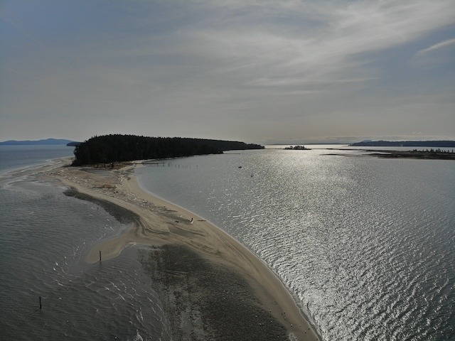
Sidney Spit itself is a sandy, narrow strip of land stretching north between Miners Channel and Sidney Channel. The spit forms one edge of a broad lagoon of sheltered water bordered by a shorter spit of sand on the west side. At the park, there are mooring buoys, a government dock, picnicking and camping facilities. The sandy beach with its protected, shallow waters is great for swimming and provides a lots of space to lay around soaking up the sun or taking a walk along the kilometers of beach found here.
The park is very popular in the summer months with lots of pleasure boats and sail boats moored in the bay and landed on the beach. There is also a passenger ferry service running from the long weekend in May to the end of the long weekend in September. The Sidney Spit Ferry departs from Port Sidney Marina at 9835 Seaport Place.
The spit’s tidal flats and salt marshes are located on the edge of the Pacific migratory bird flyway, so there are great opportunities for bird watching during spring and fall migrations.
The rest of Sidney Island is privately owned by a strata corporation and there is no public access to these lands
Plant Life
Sidney Island is in the south coastal climatic zone and the variety of vegetation you can find includes; Douglas fir, yew, hemlock, Garry oak, red cedar, arbutus, big leaf maple, and flowering dogwood. Much of the old growth Douglas fir on the island was logged during the two World Wars. Smaller vegetation includes the introduced and ubiquitous Scotch broom, wild rose, western fescue, and orchard grass to name a few.
The History
Sidney Island was originally named Sallas Island (as a side note, the Sidney ferry is named Sallas) and was first settled during the days of the 1858 gold rush since it was on the route running from Victoria to the Fraser River. There was vegetable and sheep farming on the island and there still remains, a 50 tree orchard on the privately owned portion of the island.
From 1906 to 1915 the Sidney Tile and Brick Company operated a brick manufacturing facility, now within the area of the marine park using the clay deposits found there. You can still find red bricks strewn along the shoreline and in the underbrush. Some people use them to make monuments along the beach. In my mind, another that’s just another form of graffiti and not recommended!
In 1910, a group of businessmen purchased the island as a hunting preserve. They brought in fallow deer from Europe, which can still be seen on the island today, but are becoming a problem since there is no natural predation.
In 1981 the northern tip of the island became the Sidney Spit Provincial Marine Park and in 2003 it became part of the Gulf Islands National Park. It comprises a total of about 400 acres of the northern tip of the island.
Paddling There
The shortest route to Sidney Island, particularly if your goal is to head to Sidney Spit and the Gulf Islands National Park is to launch from Sidney. A good spot to launch is the beach at the public boat launch in Tulista Park, which is just off Fifth St before driving into Sidney. You must pay for parking if you use the boat ramp parking lot. Optionally, you can put in on a public beach access on the end of Amherst St. There is limited parking here but it is a good launch site. The crossing from either of these launch sites to Sidney Spit is about 2 3/4 nm (3 miles or 5 km). If you would like more of a paddle and see a little more of James Island on the way, you can put in at Island View Beach, which is just over 5 nm (5.75miles or 9.25 km).
I opted for a circumnavigation of Sidney Island leaving from Island View Beach. I chose to cross over to the south end of Sidney Island and work my way up the east side of the island. It is about 3 nm to the Sallus Rocks off the southwest tip then another 1 nm to Wymond Pt, the southern most tip of Sidney Island. It’s another 3/4 nm to round Hamley Point at the southeast corner before you begin running up the north east side of the island along Miners Channel.
The morning I did the crossing, the skies were mostly clear with a slight haze, so you could see the shape of Mount Baker and the Sisters rising behind the San Juan Islands in the background. There were lots of sea birds to be seen on the way including cormorants and common murres and there were some Harlequin Ducks in the bay just past Wymond Point.
Just a mile to the south of Sidney Island is D’Arcy Island, which is also part of the Gulf Islands National Park and it has an interesting history all of it’s own. Check out our post on Kayaking to D’Arcy Island.
Once around Hamley Point it’s about a 1 1/2 nm paddle along sandstone cliffs to a large bay where the island’s marina is located. This section of the paddle wasn’t as much fun as I was heading into the breeze and the current, but hugging the shoreline I was stilling running abound 2.8 knots.
As I reached the bay I could begin to see the sandy cliffs and beaches that make up the northern half of Sidney Island. On the right, across Miner’s Channel is Halibut Island and just beyond that are the guano covered sandstone cliffs of Mandarte Island. Mandarte Island supports the largest seabird colony in the Strait of Georgia. The island is a First Nation reserve and approximately 8000 sea birds nest on this island. Mandarte is about 1 nm across Miners Channel from Sidney Island.
Crossing the bay, it is another 2 nm to the start of Sidney Spit and depending on the tides it is another 1/2 nm or so before you can cut through the spit into the lagoon. If the tides are too low or too fast against you may be faced with continuing out and around the tip of the spit, another 1/2 nm or so. You could also opt to get out of your boat and carry across the spit as it not very wide. Luckily, riding the current, I just managed to sneak through the rapidly narrowing, very shallow passage into the sheltered waters on the west side. There were a flock of Brant Geese hanging out on the shore as I passed through the gap.
There is a heck of a lot of beach to explore at Sidney Spit, but sadly, on this day the wind was blowing around 10 knots and quite chilly. I was also limited in time, so after a quick photo session on the spit it was back on the water.
I crossed the lagoon with the wind at my back turned south onto Sidney Channel. With the help of the current, my speed was pushing past 5 3/4 knots for run to the south end of James Island.
James Island sits between the Saanich Peninsula and Sidney Island and is very beautiful too, with miles of sandy beaches surrounding the island. For more on information on this island check out the post I did for Ocean River Sports – Circumnavigating James Island.
Paddling across the south end of James Island, I stopped to take a couple of photos of a beautiful wood sail boat that had washed ashore here. It had probably broken loose from its moorings somewhere during one of the winter storms…sad. Leaving the southwest corner of James Island it was the final push across Cordova Channel for the 1 nm crossing back to Island View Beach.
The paddle was 14.2 nautical miles in total. It’s always fun getting out of the boat on my aging 66 year old legs and staggering up the beach like a drunken fool! And, the driftwood logs stacked up on the boat ramp at Island View don’t make it any easier! Hopefully the parks folk will clear that up someday.
I departed at Island View Beach at 9:30 and arrived back at Island Beach around 14:30, roughly 4 1/2 hours of total paddling time.



Thanks for this Bruce!